

What is the largest magnet you have ever seen? I’ll give you a hint: You are standing on it. Yup, it’s the Earth! But you say, “How can that be?” Deep under our feet, buildings, and roadways, is the Earth’s core. The core is about 4500 miles wide and the outer part is liquid (molten) and the inner part is solid (nickel and iron). It is this core which is responsible for the earth’s magnetic field – think North and South poles. So, the Earth is like a huge bar magnet.
Early indications of the Earth’s magnetic field were detected via a simple compass used by seafarers for at least the past 1000 years. So where does that put us today? Zip ahead to now.
Magnetics have been a fascination for generations and have been studied with regards to radio communications, cell phones, motors, generators, and more geologically and environmentally for mineral exploration, coal mine hazard detection, unexploded ordinance detection, location drums of toxic and hazardous wastes, underground storage tank locating, as aids for directional drilling, and for oil exploration.
By recording and analyzing minute changes in the magnetic field proximate subsurface features it may be possible to determine the source of the readings and thereby evaluate the appropriate course of action: exploration, digging, drilling, excavation, etc.
Magnetometer surveys are completed at the ground surface or via airborne methods (drones, aircraft, and satellites). Depending on the survey goals, various magnetometry can be used such as fluxgate, gradiometer, vector, potassium/cesium vapor, or proton procession magnetometers.
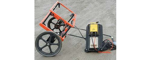
Encorus has used magnetometers such as the EM-61 to locate buried metal objects like tanks and utilities. The Geonics EM-61 is a time domain metal detector which detects both ferrous and non-ferrous objects with excellent spatial resolution, perfectly suited to brownfield site mitigation or locating tanks and unexploded ordinance.
Another type of magnetometer is the Geonics EM-31 which is used to determine terrain conductivity. The EM31 maps geologic variations, groundwater contaminants, or any subsurface feature associated with changes in ground conductivity. Surveys can be carried out under most geologic conditions including those of high surface resistivity such as sand, gravel, and asphalt.
It should be noted that no single geophysical method alone can fully identify differentiate subsurface objects, as each has its inherent limitations. Generally, a suite of equipment and methods are used to fully investigate a site. For more information regarding our geophysical applications and your site-specific project requirements contact Senior Geologist Andrew Kucserik at [email protected] or (716) 592-3980 ext 149.
